Photograph Source: Mitchell O’Brien – CC BY-SA 4.0
In March, the Missoula District Court remanded the Round Star Project back to the Flathead National Forest to address problems in the analysis. The Flathead NF described the Round Star project as a vegetation treatment to reduce the likelihood of a stand-replacing fire within the wildland urban interface (WUI). The project would cover 28,000 acres. This includes logging of 6,600 acres, thinning an additional 2,866 acres to reduce tree densities and fuel loading. Then, prescribed fire across the landscape would further reduce the fuel load. Twenty miles of new roads would be needed. In its Environmental Assessment, the Forest Service admits its own management history lies at the root of its admitted forest dysfunction. So, now the classic example of repeating the same process and expecting a different outcome.
This project would supposedly increase the diversity and resilience of the forest, as if native forests lack diversity and resilience if left alone. They survived and provided fish and wildlife habitat long before we came along. Forests don’t need us. We need forests and the functioning watersheds they provide when left alone in a natural state.
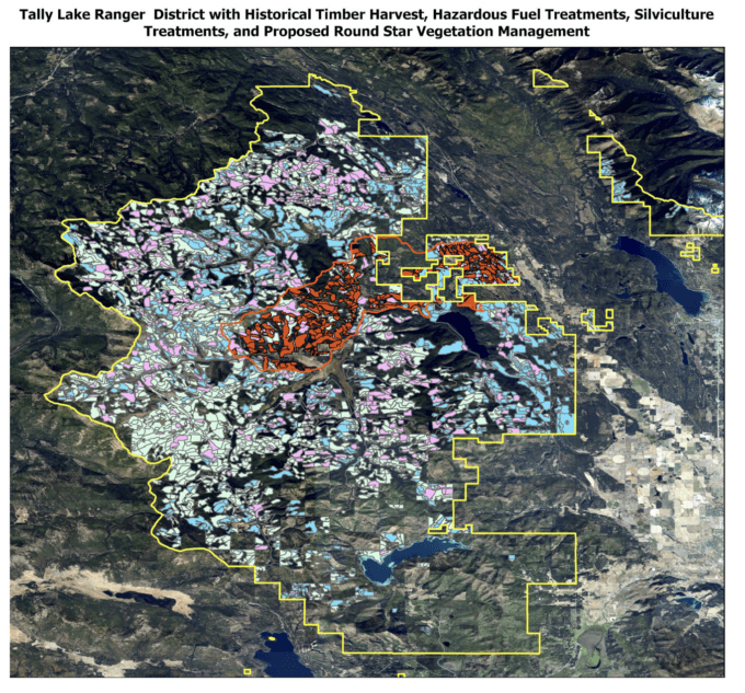
Using the Forest Service’s publicly available data for past forest activities, road and trail densities, I mapped the Tally Lake Ranger District and its past timber manipulations. These show that 74% of the entire Ranger District has suffered some form of timber manipulation in the past and has an overall road and trail density of 2 miles/square mile. This is too dense for species such as grizzly bears, Canada lynx, elk and others. The map shows the Tally Lake Ranger District outlined in yellow, and the Round Star project and its treatment units in red. The other colored areas are past vegetation management projects. What is clear is that this project and other adjacent projects are going after the few remaining patches of forest that might have timber.
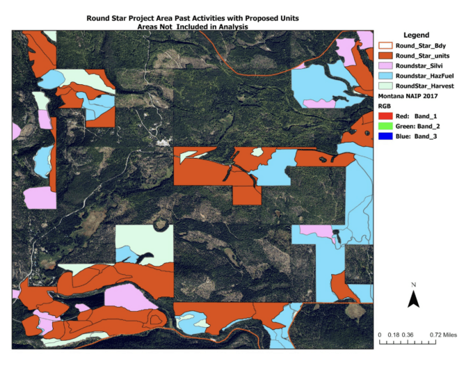
But that is not the complete picture of past disturbance because these data files did not include other disturbed areas. The aerial image below shows a small portion of the project area with the past projects and Round Star proposed treatments. Numerous unmapped past clearcuts are visible as light-colored patches among the few remaining mature forest patches in dark green. What becomes clear is that, over time, the Flathead NF has manipulated almost the entire area.
The Environmental Assessment for the project claimed that “The temporal scale of the effects analysis extends 100 years into the future, enough time for dense forest conditions to provide multistory lynx foraging stands.” But the evidence is clear from these images and our analysis that the Forest Service has not, and if history is any proof, will never allow these dense forest conditions to develop in the ongoing gold rush that is today’s wildfire hysteria enabled logging of our forests and destruction of wildlife habitat and watershed function. This is also evidenced by the additional project (Cyclone Bill at 41,000 acres) proposed adjoining Round Star.
This is a picture of the disaster that has become the Tally Lake Ranger District. The Forest Service has, in the past, logged and burned nearly all the forested areas in the Tally Lake Ranger District. It is clear that their past efforts have made the situation worse, and their answer is to do more of the same – cut down any tree that could be made into 2 x 4s before they burn in a wildfire, or insects kill them, both of which are natural events in the life of a forest. When you consider that nearly 90% of forest fires are human caused, 20 additional miles of roads and human access worsen the situation.
This is all enabled by the Healthy Forest Restoration Act (HFRA) and their new tool, Emergency Declarations, which allow the Forest Service to evade public accountability by excluding these activities in the WUI from any meaningful public review. The Round Star project lies within the WUI for the Flathead NF, which the Forest Service has exaggerated to cover a huge area of the Forest.
The HFRA looks at the number of structures per square mile and when you map structural density in these National Forests, you find minimal WUI acres. The evidence seems clear that these new tools are enabling the Forest Service and timber companies to continually log and burn our forests and destroy fish and wildlife habitat. For example, the history of logging in the Tally Lake Ranger District has dramatically reduced sightings of Canada lynx in recent years. Yet no habitat is left to recover to the mature forest and secure habitat animals like lynx, grizzly bears, wolverines, elk and others need.
A major problem lies with local governments granting permits in forested areas to build houses and subdivisions, often with no regulation requiring home hardening such as metal roofs and no fire protection. Then they want the Federal Government to come in and spend taxpayer dollars under the guise of fire risk, so they can use this law that allows them to avoid public scrutiny through a true analysis of the forest condition and actual wildfire risk to residences.
There is a term called “regulatory capture” in which the regulatory agencies, created to act in the public interest, are dominated by the industries they are meant to regulate. Instead of protecting consumers, the “captured” agency advances the commercial or political interests of that industry, resulting in reduced public welfare, higher costs, and industry-favorable policies. Is this where we are?
Our organization was one of those who took this case to court with the judge noting that “At worst, the agency relied on the Community Plan and a WUI boundary that was not compliant with HFRA.” Unfortunately, our group of organizations take a detailed look at these projects and expose this failure to serve the public trust.