
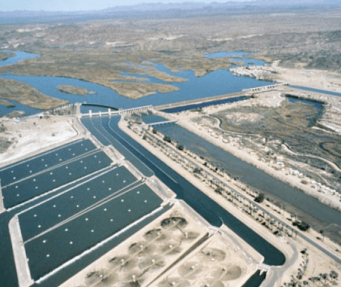
Imperial Dam, Desilting pools, and beginning of All-American Canal (lower right).
My idea of driving five hours across the desert from Indio in the lovely winter light to the Imperial Dam on the Colorado River outside of Yuma, Arizona was a reaction against all the palaver in the press about water agreements not coming to pass and hundreds of millions of federal dollars pledged here, there, thither and yon. I thought seeing and describing the dam complex on the Colorado about 40 miles from the US/Mexican Border as the Coot flies might add something concrete (sic) to my understanding.
I should have figured that because it was on the Border, nothing concrete, abstract, liquid, solid, animal, mineral, vegetable or metaphysical would manifest in any form easy to describe. When I found myself stalled in traffic on the main drag through El Centro and began looking around at the hodge-podge of business signage in Spanish and English, the various bright colors of the walls, the great graffiti, I knew I was back after 30 years. Ramon Ayala’s beautiful “Que Casualidad” came on the radio and I started singing along andswearing at traffic in Spanish, thrilled for a moment to be back in the culture of chaos called the Border, as impervious to organization by the walls of Bill Clinton et al as it may yet prove to be to all the cartel gunmen.
Downstream from the Hoover Dam, the Colorado River flows through the Imperial Dam outside of Yuma and goes from there in different directions: the greatest share to California through the largest canal in the US; small amounts to Arizona and Mexico. A border defines this river: Mexico should get nothing but a silt-choked creek; the people President Herbert Hoover called “wild Indians” should get nothing at all despite reservations along the river with “senior water rights” acknowledged by treaties and adjudicated in federal courts; and the land surrounding the river and its dams is federal, either military or Indian reservation. It almost feels as if the United States defeated Mexico and the Navajos, Utes, Apaches and other Native Americans yesterday, and the US is still occupying a region in southern Arizona and New Mexico called La Mesilla, bounded by the Colorado River in the west, the Gila River in the north, and partly by the Rio Grande in the east, which Mexico sold to the US in 1853 (Gadsden Purchase) a few years after it lost California, Nevada, Arizona, Utah, and western Colorado and New Mexico in the Mexican-American War (1846-48). La Mesilla now contains: American bombing ranges: a huge American testing site for artillery, mines, military vehicles, and desert training for troops; an American Marine airbase; Indian reservations; absentee corporate agribusiness; Yuma AZ and a few small towns. Lost in the middle of a huge American desert-military complex is the Imperial Dam on the Colorado River.
But it’s hard to recognize the Imperial Dam, or the Parker Dam, which creates Lake Havasu upstream from it, because both are so thoroughly overshadowed in importance by the mighty Hoover Dam, which prevents floods, produces hydroelectricity for about a million and half people in three states, irrigates 1,500,000 acres, and provides water for 16 million people. A congressional deal to dam the river had stalled for years because the states couldn’t agree on water rights, when Herbert Hoover, Secretary of Commerce in the Coolidge Administration, brokered a settlement, splitting jurisdiction between the upper states (Wyoming, Colorado, New Mexico, and Utah), and the lower states (California, Arizona, and Nevada), giving 7.5 million acre feet to each side and leaving the distribution of water within their halves to the decisions of the two groups. As president, in 1928 Hoover signed the final Colorado River Compact after six years of wrangling in Congress, and the Boulder Canyon Project Act, which provided the funding for the Hoover Dam, the downstream dams and the All-American Canal; and he oversaw the beginning of construction of the Hoover Dam until he was defeated in 1932 by Franklin D. Roosevelt.
The Colorado River Delta starts south of Imperial Dam. The river deposited billions of tons of silt gathered in its course from the Rocky Mountains to the Sea of Cortez, creating very rich soil if flooding could be controlled by dams and the water channeled into irrigation canals and ditches. You can see the fan of lush natural growth that extends out from the Imperial Dam going south. It continues to widen and deepen until it ends in the rich agricultural valley of Mexicali, developed in the early 20th century mainly by Americans like Harry Chandler of the Los Angeles Times, who owned 2 million acres there in the early 20th Century. Mexicans seized their land back by force in 1937, but foreign capital has regained control of much of that farmland since.

All-American Canal.
These three very rich valleys, Imperial (including Palo Verde and Coachella north of Salton Sea) in California, Yuma and the Gila River bottomland in Arizona, and the Mexicali Valley, are all parts of this delta, which now receives Colorado River water through ditches and furrows. There are no more great floods adding to the topsoil of the region, only local flash floods from the surrounding mountains and escarpments.
On his way home from the White House after defeat in 1932, Hoover paused near the construction site of the Hoover Dam (shortly thereafter to be renamed the Boulder Dam until 1947), and told reporters following him: “The waters of this great river, instead of being wasted in the sea, will now be brought into use by man. Civilization advances with the practical application of knowledge in such structures as the one being built here in the pathway of one on the great rivers of the continent. The spread of its values in human happiness is beyond computation.”
In fact, computation of human happiness would be better left “beyond computation” in this region rather than bragged about by Herbert Hoover. Yuma County AZ has an average annual per capita income of $18,418, despite containing a city of nearly 100,000 people and the above mentioned military bases. The only poorer Arizona counties are dominated by Indian reservations: the largest being the Navajo, Hopi, Apache, and Tohomo O’odham. Imperial County is the poorest county in California, with an average per capita income of $16,409, despite its seven cities around the vast plantations of row crops and dates. Income would probably be higher in these counties if more of the profits stayed there. There are reportedly some small farms left amid the fields of absentee agro-corporations, but equipment yards, sheds and loading docks are the rule, not farm houses.
But Hoover, of course, was thinking about the vast citadel of civilization on the coast, Los Angeles and its suburbs.
I did eventually find a view of the Imperial Dam when I was permitted entrance for 15 minutes to Hidden Shores Resort, which lies beside the dam’s forebay. I could see the diversion canal and gates to the Yuma and Gila River canals but could barely see anything of the gates that stop the flow of the river and steer the largest part of it into the beginning of the All-American Canal. The entire Imperial Dam is carefully protected by fences and stern No Trespassing signs put up by the federal Bureau of Reclamation and there is even a sign saying “See Something Say Something,” presumably to obstruct spies from taking pictures of Coots or from throwing something into the water that would make it even worse than it is now. The government warns against eating too much of any fish caught in the All-American Canal due to high levels of Mercury, PCBs and Selenium, and Coots, although they make a lovely croaking sound, aren’t riveting entertainment.
The resort appears to be a concession of the federal Bureau of Land Management. It includes 800 vacation sites, divided between RV hookups, rental homes, and privately owned homes. It advertises itself as “built with family values in mind.” It is a resort that backs onto an artillery range, but stands on the shore of a stretch of tree-lined river upstream that runs through the beautiful Arizona desert. It has a clubhouse, heated pool, nine hole golf course, a small pitch and putt course, boat docks and other assorted amenities for vacationing families. Yet, clearly, the dam that has created the forebay in which people water ski and fish or simply run their boats, is very off-limits and dangerous.
My intent of seeing the Imperial Dam and perhaps understanding something of how it worked was frustrated. I was particularly interested in seeing the three huge pools and their scrapers, where silt settles before the water goes into the All-American Canal to California and is then scraped into the remains of the river that flows to Mexico. I wanted to know how the gates on the dam worked and how much of the total flow of the river they could divert if the allocations of water were to change.
I drove back to California on I-8 and stopped at one turnout to look at the All-American Canal through a fence posted by the Imperial Irrigation District, which, along with the Pentagon, the Department of Interior, and the Border Patrol, really runs this little corner of the world where California and Arizona collide north of the Border. The ‘net informed me that more than 500 people have lost their lives in that canal. As someone who grew up swimming in canals in the Central Valley I could well imagine. The canal was wide, deep, fast moving and it was cement lined. No way out at all. In recent years, however, the district has installed ropes with floats on them across the canal in certain places where, if you last long enough, maybe you can catch hold and haul yourself out. This monster of a canal runs right along the Border from Yuma to Calexico, a far more dangerous obstacle than Trump’s wall or the Border Patrol. Its largest tributary, the Coachella Water District Canal, goes north up past Salton Sea, irrigates the rich Coachella Valley, and ends in the man-made Lake Cahuilla in La Quinta, last of the great Snowbird burgs of gated communities of which Palm Springs is the paradigm.
It is reported that 10,000 workers a day cross the Border south of Yuma to work in those fields during the winter season. Thousands more cross daily from Mexicali to Calexico to work in Imperial County in winter. The work is seasonal, the amount of housing is inadequate, rents are exorbitant, and government is rarely helpful.
This trip was a failure. I couldn’t get to see the Imperial Dam, the great cement hand whose fingers divide the flow into smaller channels: the big one to California, the smaller ones to Yuma Valley and the Gila River; the smallest, silt-full creek to Mexico. There are pictures of it on the ‘net.
I seemed to get a bit of everything but the subject. I didn’t even get a chance to stand for a reverent moment in the Yuma Penitentiary before the photo of the first man arrested in the Mexican Revolution, Ricardo Flores-Magon. But I found a fine restaurant on the corner of 4th Avenue and 2nd Street coming into town on Winterhaven Drive, called Tacos Mi Ranchito. It’s a small orange box of a building, surrounded by parked pickups. Good food, sardonic company.
