Ancient Pathways
Just south of the Montana State line, in the lower Big Horn Basin, sits Natural Trap Cave: a large circular hole in the ground with a 30-foot vertical drop to a cavern below. You can’t see it until you are nearly upon it. Today it is covered by a metal grate, but for thousands of years unsuspecting animals fell into it and died. Archaeological excavations have produced a trove of skeletal remains of ancient Pleistocene mammals, including mammoths, camels, horses, enormous short-faced bears, American cheetahs and the Beringian wolf.
Beringian wolves, now extinct, once inhabited Beringia and Alaska, which were connected by a land bridge during the last glacial maximum. They were a bit larger and more robust than the gray wolf, and a bit less so than the dire wolf living south of the ice sheets. But Wyoming is a long way from Alaska, let alone Beringia, so how would a Beringian wolf fall into Natural Trap Cave?
Around 26,000 years ago, a 2,000-mile long corridor began to open up east of the Rocky Mountains as the Cordilleran and Laurentide ice sheets gradually receded, thus allowing Pleistocene mammals to extend their ranges. For reasons still largely unknown, but including hunting by aboriginal Americans and a changing climate, many of those species became extinct 11-12,000 years ago—the dire wolf and the Beringian wolf included.
There were no fences or highways back then to impede the movements of animals, just natural traps and obstacles of various kinds. Despite this, many species of animal went extinct in a relatively short span of time. Leaping forward to the present, the scene is dramatically different. Wildlife habitat has been greatly fragmented and altered by human activity, and many new impediments to animal movement have been created: fences, highways and forest roads galore, as well as housing developments, airports, mines, energy fields, and myriad other impediments. In addition, forests have been cut down, rivers dammed and grasslands damaged by livestock. On top of it all, rapidly accelerating changing climate, caused by us human beings, is altering habitats in a mere eyeblink of geological time. Some ancient North American denizens persist, including mule deer, pronghorn, cougars and gray wolves, but for how long? It’s up to us to see that they and other native species are able to persist long into the future throughout as much of their historic habitat as feasible. This will require us to ensure that their habitat needs are met, including functional migration routes and dispersal corridors.
Early this millennium two ancient ungulate migration routes were discovered in the upper Green River Basin, just over the Absaroka and Wind River Mountains from the Big Horn Basin. These pathways have been in use for thousands of years, possibly dating back as far as the Pleistocene Epoch. The most famous, the “Path of the Pronghorn,” was discovered in 2003. One particular herd of these fleetest of terrestrial herbivores, the prey of an American cheetah long ago, makes an astounding annual migration from its wintering ground in the Red Desert to Jackson Hole for the summer, then back to the Red Desert for the winter. In 2013, a second ungulate migration corridor—a 160-mile long mule deer migration corridor from the Red Desert to the Hoback Basin, roughly parallel to the pronghorn corridor—was discovered. It has existed for thousands of years, with deer moving north in the spring and south in the fall, every year. The invention of radio and satellite telemetry, as well as trail cameras, enabled the discovery and documentation of these seasonal migration routes.

Since the discovery of these migratory corridors, efforts have been made to remove or mitigate impediments to animal travel in order to preserve the ancient pathways and the herds that depend on them. For example, the “Trappers Point Project” includes two strategically placed highway overpasses on Highway 89-91 west of Pinedale, Wyoming.

Further south, Interstate 80 and Union Pacific Railroad tracks present an impassable barrier to most ungulate movement. Recently the Washington Post published a special article on this problem. It turns out that ancient mule deer and pronghorn migration routes once extended south of I-80 and the Union Pacific Railroad tracks, but now go mostly unused because of the barriers. The article stresses the importance of building wildlife crossings along I-80 for the express purpose of facilitating the safe crossing of deer and pronghorn.
To promote the building of wildlife crossings, Wildlands Network, an NGO with headquarters in Salt Lake City, introduced the Wildlife Corridors Conservation Act (WCCA) into Congress in May of 2019 and will do so again in 2020. The WCCA is supported by hundreds of conservation and sportsmen organizations, plus outdoor recreation brands including Patagonia, Osprey Packs, and Petzl America, and also by esteemed scientists, including Wildlands Network co-founders Michael Soulé and Reed Noss, and renowned biologist Edward O. Wilson.
Yellowstone-to-Uintas mega-corridor
Millions of people have heard of the Yellowstone to Yukon Conservation Initiative, an ambitious visionary project involving hundreds of organizations in Canada and the United States working collaboratively to reconnect critical wildlands between the greater Yellowstone Ecosystem and the Yukon. However, very few people have heard of the Yellowstone to Uintas Connection.
The Yellowstone to Uintas Connection (Y2U) is the landscape stretching from the greater Yellowstone ecoregion to northwest Colorado via the Uinta Mountains of Utah. It is also the name of an organization with the mission of protecting and restoring ecological function to this landscape.
When you drive I-80 from Laramie to Salt Lake City, you first round the north end of the Medicine Bow Mountains, then head west across some 250 miles of high sagebrush steppe to Evanston, Wyoming in the southwest corner of the state. About 80 miles east of Evanston you cross the Green River as it flows to Flaming Gorge Reservoir from its headwaters in the lofty Wind River Mountains to the north. From there westward, the Uinta Mountains are visible to the south in a long east-west trending line of summits.
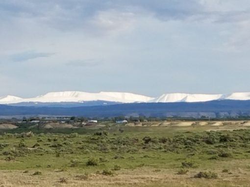
The Uinta Mountains run parallel to the Wyoming border just inside Utah and jut into Colorado at Dinosaur National Monument. They are Utah’s largest and highest mountain range, with many peaks over 13,000′. The High Uintas Wilderness, established in 1984, encompasses 456,705 acres of the high country and is surrounded by a broad band of mostly roadless forest.
Upon leaving Evanston you descend 1,400′ in 30 miles to Echo Junction, Utah where I-84 to Ogden branches from I-80 to Salt Lake City. To the south and east are the Uintas. To the north rise the Monte Cristo Mountains, then the Bear River Range, which terminates at Soda Springs, Idaho some 120 miles to the north.
The Bear River Range is a long narrow north-south trending range between 9,000 and 10,000 feet in elevation. The 44,523-acre Mount Naomi Wilderness, established in 1984, is located in the central and highest part of the range just south of the Idaho border. The range’s namesake, the Bear River, heads in the western Uintas and flows in a long sinuous loop entirely around the Bear River Range to empty some 350 river-miles later into the Great Salt Lake. It is the longest river in North America that does not ultimately reach the ocean. Famous trapper and explorer Jim Bridger reportedly followed the river downstream to “discover” the lake in 1824. Today, it is all farm and ranch country along the river, with numerous small towns dotting the landscape.
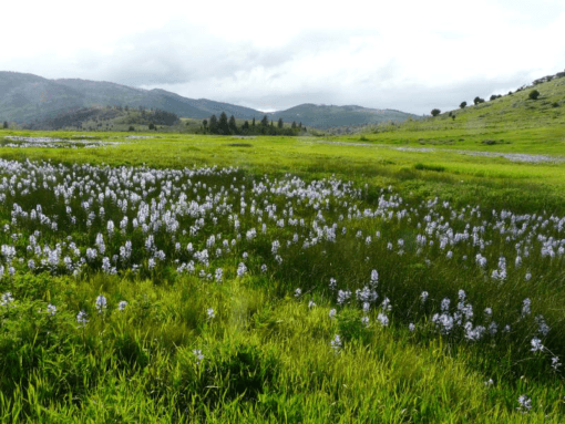
View of Bear River Mountains from Kiesha’s Preserve
The Bear River Mountains parallel Wyoming on the Idaho-Utah side and form a right angle with the east-west trending Uintas. Together they are key links in a mega-corridor for wildlife between the Northern Rockies and the Southern Rockies of Colorado.

Y2U important for carnivore conservation
Most of this vast country, from Laramie to Echo Junction, is jackrabbit, coyote and pronghorn habitat. One would not normally think of it as habitat for wolverines, lynxes, cougars, wolves and bears. Yet, all these species lived in the mountainous regions of western North America until white trappers and the settlers that followed began killing them off. Wolves were almost totally eradicated from the contiguous 48 states by the 1940s, yet recently a family of six wolves has been confirmed to be roaming extreme northwest Colorado, only 15 miles from the Wyoming and Utah state lines. No doubt they came from the reintroduced population in the greater Yellowstone ecoregion, but how did they get to this part of Colorado, so rugged and remote it was one of Butch Cassidy’s hideouts?
The geography suggests two possibilities: down the Green River corridor or down the mountains along the western Wyoming border, including the Bear River Range, thence into the Uinta Mountains and east into Colorado. The two routes converge in the area of Brown’s Park, Colorado, where the wolves are living. From there, the Colorado Rockies are within relatively easy reach for a far-ranging carnivore. Another wolf, wearing a satellite collar, was photographed last year in Colorado’s North Park. It might well have traveled via the Bear Rivers and Uintas, though evidently the nonfunctioning collar left its exact route unknown.
The Uintas are historic habitat for all native forest carnivores, including cougars, black bears, grizzly bears, fishers, wolverines and lynx, as well as for bighorn sheep, elk and deer. All these species could once again live there. In fact, since their reintroduction to Yellowstone National Park, there is documentation of wolves traveling into Colorado via the Bear River-Uinta corridor. Female 341, found dead of sodium fluoroacetate (Compound 1080) poisoning near Meeker, Colorado in 2009, is one unfortunate example.
The famous and beloved wolf known as Limpy, from Yellowstone’s Lamar Valley, was found caught in a coyote trap within a few miles of Echo Junction in the fall of 2002. He was translocated to Grand Teton National Park and eventually returned to Yellowstone, where he became the alpha of his own pack. Sadly, he was gunned down in the upper Green River Valley on March 28, 2008—the very first day of the first delisting of gray wolves in Wyoming.
Another young wolf from the Yellowstone country, upon arriving at Echo Junction or thereabouts, kept to a southerly course along the Wasatch Mountains and the high plateaus of central Utah. She made it all the way to the north rim of the Grand Canyon and was named Echo by school children to commemorate the return of wolves to their ancestral homeland. Not finding a mate, Echo turned back and was soon shot dead by a coyote hunter near the Tushar Mountains in south-central Utah in late 2014.
In February of 2014, a wolverine was photographed high on Elizabeth Ridge on the north slope of the Uintas. The wolverine must have come from the north, since there are currently no known resident wolverines in Utah or Colorado. In July of 2016, another wolverine, a young female, was found dead on the side of a road at the eastern foot of the Bear River Mountains. Prior to these recent records, “the last documented wolverine in Utah was shot near Dinosaur National Monument in 1979.”
Canada lynx are no strangers to the Uintas. There were 10 verified and 17 reliable records of the presence of lynx in the Uinta Mountains in the 20th century. Certainly the elusive cats were present for centuries prior to that; and 2000 satellite telemetry has recorded numerous incidents of lynx visiting the Uintas from the reintroduced population in the San Juan Mountains of southwest Colorado.
120 miles due north of Elizabeth Ridge is Commissary Ridge, where the Wyoming and Salt River Mountains of western Wyoming merge. There are lynx in those mountains. The two ridges point at each other, but the route between them for forest carnivores is roundabout. From Commissary Ridge to the Bear River Valley its mountainous terrain all the way. Lynx, wolverines, wolves and other large carnivores, as well as deer and elk, would have little trouble traversing the few miles across the sparsely populated Bear River Valley to the Bear River Range. A strategically placed wildlife overpass or two on Highway 30 in southeast Idaho would certainly help, as would wildlife overpasses along I-80 east of Echo Junction.
The Bear River link
In 2006, the Forest Service identified the Bear River Range as a “regionally important wildlife corridor.” Conservationists with Wild Utah Project then made a “least cost path” analysis that showed the Bear River Range to be the most likely route for lynx moving between the Uintas in Utah and the mountains of Wyoming. It is probable that Colorado and Wyoming lynxes continue to travel via the Bear River Mountains and the Uinta Mountains.
The importance of the Bear River Range as a wildlife movement corridor for large mammals is clear. What is not often realized is that the Bear Rivers, in conjunction with the Uintas, are literally the only mountainous link between the Wyoming Rockies and the Colorado Rockies; and the only one that contains forest habitat. It is a vital link in the Yellowstone to Uintas Connection, and in the entire “Western Wildway.” Protecting the Bear River Mountains is therefore vital to wildlife conservation in the American Rockies, especially for forest carnivores such as the lynx and the wolverine.
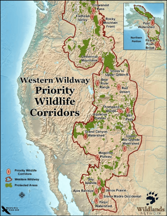
In 2011, at a Wildlands Network rendezvous in Bozeman, the author made a presentation on this vital wildlife corridor and lobbied to have it included in the top 20 “priority wildlife corridors” in the Western Wildway, which stretches along the “Spine of the Continent” from the Sierra Madre Occidental in Mexico to the Brooks Range in Alaska. The pitch was evidently convincing.

While the Bear River Range is surely one of the most important wildlife corridors in North America, especially for mammal carnivores, it is also one of those in greatest peril. It has been subjected to unremitting assault by human beings since the days of the beaver trappers. The list of inflictions includes livestock grazing, heavy OHV/ATV use, timber cutting and potash mining.
In addition, there is a deliberate effort on the part of state and federal agencies to prevent the most reviled and feared native carnivores—wolves and grizzlies, respectively—from naturally expanding their current ranges southward from the greater Yellowstone ecoregion via the Bear Rivers or any other route. Most of Wyoming, including all of southwest Wyoming, has been officially designated by the state a “Predatory Animal Management Area,” which means that wolves enjoy no legal protection and no restrictions on killing them. Despite their endangered status, grizzlies that venture into the upper Green River and Gros Ventre River watersheds run a high risk of being killed as payback for cattle allegedly killed by them. Proactive nonlethal remedies to livestock predation are known and available, but are evidently deemed too onerous a burden to require of the cattle growers reaping a profit from the public land. The Yellowstone to Uintas Connection is a plaintiff in a law suit opposing the renewal of the grazing leases. grizzlies in the crosshairs
Healing the ecological wounds
The Yellowstone to Uintas Connection (Y2U) is a 501(c)3 conservation organization created in 2012 by John Carter and Jason Christensen in response to the watershed and wildlife habitat degradation in the Bear Rivers and the Uintas. Carter is a Utah State University alumnus with a Ph.D. in ecology. His love of the land and of wildlife includes a fierce desire to restore and protect them. Beginning in the early 1990s, he and his young partner, Jason Christensen, began buying private property parcels in Paris Canyon of the Bear River Range in southeast Idaho and built fencing to exclude livestock. They named the property Kiesha’s Preserve after Carter’s beloved Akita, Kiesha, who accompanied him on numerous outings for pleasure and work. Today, Kiesha’s Preserve encompasses 900 acres where Carter has monitored and recorded, year after year, the natural recovery of the watershed from decades of livestock damage. Says Carter: “To date, 824 acres have been placed in a conservation easement. Livestock grazing was eliminated so native plants, streams and springs could recover. Our goal is to continue restoration and property acquisition with more land placed in easements.” More recently, another 90 acres in critical lynx and important mule deer habitat was purchased in the Wyoming Range.


Sleight Creek 2 & 13 years after livestock excluded
Since the summer of 2017, under the leadership of Executive Director Jason Christensen, Y2U, in cooperation with the US Forest Service and using equipment owned by Kiesha’s Preserve, has closed 16.5 miles of illegal roads and over 75 illegal campgrounds/OHV “play areas” in the lynx movement corridor in the Uinta-Wasatch-Cache and Caribou-Targhee national forests. More information on all of these projects can be found at: https://www.yellowstoneuintas.org/issues/science See also: www.kieshaspreserve.org


Christensen has also placed about 40 trail cameras along the length of the Bear River Range to record wildlife use and illegal use by cattle.

There are already numerous phosphate mines in the Caribou-Targhee National Forest. The above photograph of the J.R. Simplot Co. Smoky Canyon Mine, just west of Afton, Wyoming in the Caribou National Forest of Idaho is typical. Five more open pit mines with tailing ponds are planned in the area by Simplot. Additional mines owned by Simplot (now Bayer) have mined thousands of acres in this area. These mines not only involve lots of truck traffic, noise and dust, but are constantly expanding, which results in the permanent loss of forest and wildlife habitat, plus land erosion and stream pollution detrimental to native fish species. They also obstruct the movements of wildlife far beyond their actual footprint. Y2U will address whether the Final Environmental Impact Statements for all of the proposed new mines adequately analyze the potential environmental impacts of the projects and address potential alternatives. Y2U will file an Objection if the FEIS is inadequate in this regard and will seek legal representation to litigate violations of the intent of NEPA, NFMA/FLPMA and the CWA when necessary on all of the proposed new phosphate mines.
Yellowstone to Uintas and partner organization Alliance for the Wild Rockies are working to get Congress to pass The Northern Rockies Ecosystem Protection Act (NREPA), S. 827 and H.R. 1321. NREPA is the most comprehensive solution for protecting our nation’s wild places for future generations. It will protect iconic threatened and endangered species, biodiversity, water supplies, and will combat climate change. NREPA will protect the invaluable ecosystems of the Rocky Mountains bioregion by creating biological corridors that connect existing wilderness and roadless areas throughout the Yellowstone to Uintas Corridor.

John Carter and his Akita helpers doing research on the effects of sheep grazing in the High Uintas Wilderness.
The Uintas link
The Yellowstone to Uintas Connection, along with partner organizations including Wilderness Watch and Western Wildlife Conservancy, have submitted comments on the Forest Service’s June 25, 2019 Notice of Release of the Draft Environmental Impact Statement (DEIS) for the High Uintas Wilderness Domestic Sheep Analysis Project. Thousands of sheep are trailed up the canyons and into the wilderness area every year, where they graze the riparian zones and the fragile alpine basins to death, then are trailed back. Much of Buck’s Pasture in the West Fork of Black’s Fork (of the Green River), for example, is a dead zone. The stream bank is heavily eroded, with the adjacent meadows having lost their native plant communities and become barren. The stream bank has collapsed and there is nary a live tree or bush to be seen, with almost no native Colorado cutthroat trout remaining in the stream. The Forest Service has blamed these un-wilderness-like conditions variously on hordes of pocket gophers denuding the alpine benches, on avalanche dams breaking to release flood waters, and on tie-hacking to produce railroad ties for the railroad over a century ago. These exercises in creative hypothesizing are preposterous on their face. As a matter of fact, historical records indicate that tie hacking did not occur inside the present wilderness boundary, let alone miles inside the wilderness where the forested slopes surrounding Buck’s Pasture are steep and rugged. John Carter and Jason Christensen, with the assistance of colleagues from Wild Utah Project and Western Wildlife Conservancy, have spent literally thousands of hours monitoring and recording vegetation and stream conditions in the Uintas—conditions that have become inhospitable to many species of wildlife. It is a sad fact that much of the High Uintas Wilderness has become WINO = wilderness in name only. Uinta watershed conditions report
Like other mountain ranges in the West, the Uintas were once home to a vast herd of big horn sheep; but, as in other places, the herd was decimated by overhunting, then totally lost to diseases contracted from domestic sheep. Efforts to restore big horn sheep to the Uintas began nearly 40 years ago. However, because of the hordes of domestic sheep that graze the mountains every year, the bighorns have not flourished. Unfortunately, the herd is constantly struggling and has never been able to expand beyond a small part of the eastern end of the range where domestic sheep are not grazed. Numbering about 150, the population is only one third of the aspirational objective set by the Utah Division of Wildlife Resources. It survives only due to occasional supplementation and to the killing of mountain lions.


Left: Uintas north slope meadow (West Fork of Blacks Fork) that has been subjected to sheep grazing for 100+ years.
Right: Meadow in a nearby north slope drainage (Middle Fork of Beaver Creek) closed to sheep grazing 30+ years ago.
Destroyer / Savior
We Homo sapiens have caused species extinctions in all parts of Earth we have come to occupy. We are the great destroyers. We do it without necessarily intending to. Rather, with perhaps a few exceptions, it is a byproduct of the ingenuity we apply to other ends combined with our ignorance of “unintended consequences.” Now we are in the midst of a sixth major worldwide extinction episode mostly caused by us—one that might ultimately include us. We are at the point where we know this. And we also know that the best way to protect wild animals and plants it to leave them alone. We can’t do this everywhere, but we can do it here and there, strategically, as in Banff Provincial Park, Yellowstone National Park and Grand Canyon National Park. And we can connect these magnificent protected areas with functional corridors that animals naturally use, so that they can move with the seasons and when forced to relocate by climatic changes. It’s the least we can do in the way of recompense for all the damage we have caused. We have the resources and the know-how to successfully reconnect wild places throughout the Western Wildway. And, if we care enough, we will. A major part of the task is to reconnect the Yellowstone ecoregion to the Uintas. That’s what Yellowstone to Uintas Connection is all about.